


240608 - Roche sur Buis

randodan
User
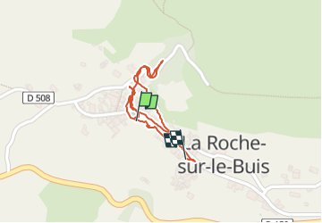

Length
891 m

Max alt
611 m

Uphill gradient
25 m
Km-Effort
1.2 km

Min alt
572 m

Downhill gradient
31 m
Boucle
Yes
Creation date :
2024-06-08 11:05:36.124
Updated on :
2024-06-08 11:59:25.191
53m
Difficulty : Easy

FREE GPS app for hiking
 SityTrail
IGN / Geographical institutes
SityTrail Plus
The world is yours!
About
Trail Walking of 891 m to be discovered at Auvergne-Rhône-Alpes, Drôme, La Roche-sur-le-Buis. This trail is proposed by randodan.
Photos

Positioning
Country:
France
Region :
Auvergne-Rhône-Alpes
Department/Province :
Drôme
Municipality :
La Roche-sur-le-Buis
Location:
Unknown
Start:(Dec)
Start:(UTM)
684475 ; 4905257 (31T) N.
Comments